Phnom Penh
i made it here to cambodia fine. I left my house at 7am to take the bus to the airport and wasn't in a hotel room until 9pm-which was actually midnight for me, with the time change (I had a three hour stopover in Bangkok Airport). A friend lent me the most recent harry potter and I finished it by the time I got to the hotel. I ended up sharing a taxi from the airport with a middle aged american english teacher and just stayed at the same guesthouse he was.
i hired myself a moto driver today-for $10 american I have been driven all over phnom penh-to see the Killing Fields, S-21 the torture camp, the National Museum, the Palace and Wat Phnom. The streets are full of people on motos, and of course, no one wears helmets. The buildings are all very old but some look beautiful-in the same way that old, falling-into-disrepair houses in venice look beautiful.
The Killing Fields were quite shocking. At first glance, you only notice the memorial building with all the skulls, but when you walk around the area there are also bits of bone and clothing poking out of the dirt. There were lots of kids around asking you to pay to take their pictures. The ride out on the moto was amazing-I admit to being nervous at first, but once we hit the dirt road (or mud road, really), I had relaxed. We passed very poor houses, farms, and a local food market. On the way back I even took a few pictures while we were moving.
S-21 was once a highschool, and then was used as a torture prison. What remains is a few beds and torture instruments and many photos of the victims. Many were only children and there were photos of women with infants.
The National Museum is in a beautiful building and opens into a central courtyard. It is mostly full of Buddha statues. The Royal Palace was cool-looked like something out of a fairy tale. I noticed then that I have a lovely sunburn. Must slather on the sunblock from now on. Lots of monks around this area, all walking with umbrellas to keep off the sun, which is apparently what I should have been doing.
The riverside area is apparently where cambodians go to hang out in the evenings-it was packed with teenagers and their motos. I also went to wat phnom, where there was a foreign group making a tv show or something-they sounded eastern european i think.
The food here is great-very similar to Thai. and spicy :)
I'm heading to siem reap tomorrow morning on the boat at 7am. My driver has arranged my ticket for me too.
Cambodia PicsHere
Angkor Wat - Day 1
So, I didn't do much in the way of planning for this trip-once I bought the plane ticket, I didn't really think much about it again until the night before I left, when I had to pack. So, perhaps it isn't surprising that I sort of had the idea that all the temples were called Angkor Wat, when in fact that is the name of the most famous one. They were all built around the same time and in similar styles though.
I started my day at the South Gate of Angkor Thom, a complex with several good ruins. Angkor Thom, particularly the Bayon inside it, is known for the giant, serene faces that are all over the Bayon temple and on the gates to Angkor Thom. They say the face is a merge of the Buddha and the king who built the temple. I had my first experience with vendors here-there are tons of people trying to sell you cold drinks, bags, t-shirts, bracelets, postcards and guidebooks, and flutes. Many of them are children, and while I fully understand why they are trying so hard to sell stuff to tourists, it was quite annoying at times. When you enter or exit one of the temples, all the vendors flock around you, trying to convince you to buy. No amount of saying no works-they will keep asking, saying things like "if you buy later, you buy from me" or asking your nationality and saying "will you buy from me if I know the capital of Canada?" These kids could beat any classroom of Canadian kids twice their age at a contest to name world capitals.
Angkor Thom is quadrangle of defensive walls totaling 12 kilometers that once protected the Khmer capital of the same name (Angkor Thom means "Great City"). Built in the late 12th and early 13th centuries by King Jayavarman VII, the walls are divided by two axes running north-south and east-west. A gateway lies at the end of each axis, four in total, facing the four cardinal directions. An additional gate, called the "Gate of Victory", pierces the east wall just north of the "Gate of the Dead", the east gate along the central axis. The significance of the additional gate is that it provided access to a terrace of the royal palace. As for the other gates, the two axes intersect at the center of the enclosed area where the Bayon temple sits.The Bayon was my first temple and possibly also my favourite. It was there that a monk wanted money from tourists to have his picture taken, in order to pay for school.
The south gate of Angkor Thom is the best preserved. It is approached from outside via a causeway that extends about fifty meters across a moat. On each side of the causeway are railings fashioned with 54 stone figures engaged in the performance of a famous Hindu story: the myth of the Churning of the Ocean. On the left side of the moat, 54 'devas' (guardian gods) pull the head of the snake 'Shesha' while on the right side 54 'asuras' (demon gods) pull the snake's tail in the opposite direction. In this myth, the body of the snake is wrapped around the central mountain—Mt. Meru—perhaps corresponding here to the Bayon temple at the center of the site. In any case, the myth relates that as the Devas pulled the snake in one direction and the gods pushed in the other, the ocean began to churn and precipitate the elements. By alternating back and forth, the ocean was "milked", forming the earth and the cosmos anew.
The central tower of the stone gate is capped by three face-towers that face the four directions (the central tower faces both out and in). Below them at the base of the gate are two sets of elephant statues that flank the entrance on both sides. Sitting on each elephant is a figure of the god Indra carrying his usual weapon—the 'vadra' (a lightning bolt). The gate itself is shaped like an upside-down "U" and is corbelled at the top (instead of arches, the builders of Angkor preferred to use corbelling to span distances). It is still possible to see where wooden doors once fitted to the gate through openings in the stone.
There is some debate as to the functionality of Angkor Thom as a whole. If it was a wall intended for defense, it was rather poorly designed, since there is nowhere along the wall for defenders to take refuge from incoming fire or shoot back from a shielded location. This is surprising since Angkor had been sacked in 1177 by Champa invaders, and one can readily imagine that its new King, Jayavarman VII would have been concerned with defense should the invaders return.
If not intended for defense, the walls may simply have been an additional enclosure around the Bayon temple, more for ceremony than for practical use. As in Southern India, the Angkor rulers built temples surrounded by walls, but usually not with walls as thick and grand as those of Angkor Thom.
Bayon was the state temple of Jayavarman VII, a powerful ruler in the late 13th century. The temple sat at the center of Angkor Thom, a walled city that served as the capital of the Khmer Empire. Four of the city's five gates sat on axis with the temple, and the walls of the city substituted for the enclosure walls normally found at Khmer temples. The walls sit at such a distance from the temple that the temple seems to rise abruptly from the ground like an artificial mountain. In fact, the temple was intended to evoke the form of Mt. Meru--the cosmic mountain at the center of the world in Buddhist cosmology. In keeping with this cosmic symbolism, the plan of the temple is based on a "yantra", a symbol used by Tantric Buddhists as the basis of mandala diagrams that represent the layout of the universe. The temple honored not just one deity, but a host of gods found throughout the Khmer empire. Its central shrine held an image of Jayavarman VII, who perhaps imagined himself as a god-King ruling in the name of the Buddha.The Bahpuon is called the world's largest puzzle-French archaeologists took it apart to do some fixing, meticulously mapping where each block had to go back. Then the Khmer Rouge came along, destroyed all the paperwork and messed all the blocks up. They are still trying to construct it, so I wasn't able to see much of it. I ended up with a guide around this temple, as I was far too polite to say no. Cost me $1 US for a fifteen minute tour, which is pricey when you think that my moto driver cost $10 for the whole day...
The temple is best known today for the gigantic face sculptures that adorn its thirty-seven surviving towers. Facing in four directions on each tower, the faces are thought to represent Lokeshvara, a Buddhist deity that projected benevolence outward to the four directions.
Bapuon was erected in the reign of Udayadityavarman II, who ruled from 1050-1066. An inscription on the temple reads: "Seeing that at the centre of Jambudvipa there rose the golden mountain, the dwelling-place of the gods, he had a golden mountain built at the centre of his city, as though in emulation. On top of this golden mountain, in a golden temple, shining with celestial light, he erected a Shiva linga in gold." The temple is used to cover the large hill visible in image one, but nowadays it has mostly vanished. Zhou Daguan, a Chinese "ambassador" in the 13th century, speaks glowingly of the temple, describing it as a "copper tower". This suggests that the entire temple may have once been sheathed in bronze plates.A short jaunt from the Baphuon is the Phimeankakas, or royal palace. It has two swimming pools, one for the king, the other for the queen, which is much bigger as the king had more than the one queen. Then I saw Tep Pranam, two large Buddha statues, only one of which is real, as apparently the Khmer Rouge sold the other. As you do. I guess that is a lot better than the Taliban destroying the statues at Baminyan, though. By the time I hit the Terrace of the Leper King and the Terrace of the Elephants, I realised I was not doing so well in the heat. I bought myself a really ugly hat/fan combo, drank 2 litres of water, and sat down to relax, having meandered my way back to the Baphuon and read for a bit. I also concluded that all those people, including the folks at Lonely Planet, who tell you that it is cooler to cover all your body with lightweight clothing than to wear shorts/tank top and expose your skin to the sun (and more culturally acceptable, perhaps), are talking complete and utter crap. That day was by far the worst in terms of how damn hot I felt and my clothes were indeed of the covering, lightweight variety.
When Jayavarman VII became king in 1181, he moved into the palace of his predecessor, king Suryavarman I. The palace sat at the center of the northern half of Angkor Thom, east of Phimeanakas temple and directly west of the eastern Baray. Jayavarman VII expanded the palace with several terraces to the east. The first, called the Elephant Terrace because of its decoration, was over 300 meters long. It probably served as the foundation for the King's main apartments, which have not survived because they were made of wood. A 13th century account says they were covered with lead tiles, and indeed, some tiles have been found alongside the terraces.As for it being culturally unacceptable to wear revealing clothing... these do not seem to be temples, at all. Sure, there are some areas where you can light some incense near a piece of Buddha statue (or a whole Buddha, but that was less common), but I didn't get the sense that in any way these were temples in use. There were a few that had wats (Buddhist temples) inside them, there I can see the argument for appropriate clothing. But really, chuck a longer t-shirt in your bag, and you can be covered when needed, which was my strategy all around Europe as well. Besides, all the tourists are running around in shorts and tank tops. I think it would be quite different if this was a less touristy place than it in fact is.
North of the Elephant terrace is the "Terrace of the Leper King." Its name derives from a misconception that one of the Yama statues depicts a legendary king who suffered from leprosy. Actually, the appearance of leprosy is an illusion caused by the lichen eating away at the surface of the stone. The terrace is sculpted with seven rows of divine characters, and was probably used for royal cremations.
Twelve stone towers face the terraces to the east. Called "Prasats Suor Prat," they are made of laterite and were probably built sometime after Jayavarman VII's reign.
Thommanon was a big underwhelming. First off, it looks much like the other temples, and this was when I realised that some of the temples might well be fun to scramble up and around, but weren't going to be visually stunning because many of them look much the same as others.
Thommanon is a small temple built at the end of Suryavarman II's reign, around the middle of the 12th century. It is nearly symmetrical to Chau Say Tevoda, another of Suryavarman's temples that stands nearby. Although the placement of Thommanon and Chau Say Tevoda neatly frame the east causeway to the Angkor Thom complex, this was probably not the original intention, since in Suryavarman's time the center of the capital was closer to Angkor Wat. Thommanon is architecturally more advanced than its predecessors. The designers took advantage of the natural qualities of sandstone, rather than simply carving it in imitation of wood.Ta Keo is huge. It was a "climber", as I thought of those temples that really were fun because of the many narrow steps you had to go up. This trip was a good workout for my legs, though it made sore a weird part of the muscle right above my knee, which is obviously not used in the course of a normal city-dwelling life. It also made me realise, as there were almost no tourists at this temple while I was there, how dodgy it is to travel alone and climb up narrow, dangerous stairs on your own...
King Jayavarman V ruled from 968 to 1001. Sometime during his reign, Jayavarman took up residence on the east side of the East Baray, and moved the capital to the west bank. He must have traveled back and forth to it by boat. Around the year 975, work was begun on TA Keo temple in the center of the new capital. TA Keo was actually called "Hemasringagiri" or "the mountain with golden peaks," meaning Mount Meru--the sacred peak of Indian lore.Ta Prohm was wonderful. It has tons of trees growing in, around, and out of the stone of the temple. It is one of a few of the Angkor Wat temples that makes you feel a bit like you just wandered out of the jungle and found them for the first time-which is why they left some of the temples in just this condition. It was here that I saw the guy who is on the front cover of the Lonely Planet for Cambodia-and since it isn't a book I have, I only knew as a result of overhearing a tour guides explination to his group. I had just bought a hanging bird thingy from him and took a picture as well, though I am waiting to get the photos I took on film developed in Scotland, so I have no idea if the picture turned out.
The temple is enormous, rising over 21.6 meters, making it one of the tallest buildings at Angkor. Its base measures 122 by 106 meters, while the outer moat stretched 255 by 195 meters, but has now vanished.
After Jayavarman V died, there was a violent usurpation by Suryavarman I in 1001 AD. Work on the temple ceased, although artisans had only begun carving the decorative work at the base of the temple. For unknown reasons, the king donated the temple to his minister Yogisvarapandita, who had served under the former king. Yogisvarapandita worshipped only the shrines at the base of the temple, since he was prohibited by law from worshipping at a higher level than the king.
TA Prohm was built during the reign of Jayavarman VII, a great king who reconquered the Khmer empire from Cham invaders in the years 1177-1181. Needless to say, the war caused great damage to the ancient capital of Angkor. The ambitious king set about making it into a proper seat of power by ordering the reconstruction of a number of temples. TA Prohm was the centerpiece of his masterplan, located roughly in the center of the capital. Though the temple covers barely 2.5 acres, its walls and moat encompass 148 acres, which would have sheltered a town attached to the temple. Here, 12,640 people lived, supported by a population of 79,365 who worked in nearby villages to provide food and supplies.Angkor Wat-it's huge, it's amazing, it takes your breath away. It was well worth the entire trip, just to be able to have seen it. With the sun shining, the beauty of my surroundings, and the wonder of being in cambodia, my only complaint was how tired my first day made me.
TA Prohm housed the deity Prajnaparamita, the "perfection of wisdom." It was consecrated in 1186. Like many Khmer kings, Jayavarman had it carved in the likeness of his mother. The Prajnaparamita statue was surrounded by 260 lesser divinities, housed in their own sanctuaries.
Interestingly, the temple was also the headquarters of a vast hospital network created by the good king. From TA Prohm, supplies filtered out to 102 hospitals located throughout the empire. The Khmer kings seem to have taken the Buddha's call to mercy into their own hands.
Nowadays, TA Prohm is in a sad state of disrepair. Voracious trees called Strangler Figs have damaged much of the complex.
Angkor Wat is a spectacular temple in southwest Cambodia, built by the vanished Khmer empire. It was constructed during the reign of king Suryavarman II, who ruled from 1113 to at least 1145. In those days, it was customary for the Khmer Empire to maintain a state temple at the heart of the city. However, when Suryavarman assumed power, the existing Baphuon state temple was dedicated to Shiva. Suryavarman worshiped Vishnu, and wished to honor him with a new temple south of the existing capital. This new state temple came to be called Angkor Wat, meaning "The city that is a temple."Getting back to the guesthouse, and particularly taking a shower, was a wonderful feeling. Riding on the moto, covered in dust (some of which stained my clothes permanently), dirty from climbing around all day, a shower quickly became one of my biggest luxuries. I ate at the guesthouse during my stay in Siem Reap as well, it was convienent and the food was good.
The land occupied by the temple measures 1300 meters north-south, and 1500 meters east-west. Unlike other Khmer temples, the entrance faces west toward Vishnu. A person entering the temple first approaches an entrance causeway that takes him across the 200 meter wide moat. On the opposite shore is an entrance pavilion measuring 230 meters north-south. Its central bays have three passages that elephants could fit through for royal processions. Past the entrance gate is a long causeway that runs for over 300 meters, decorated with mythical snake-like animals called naga. On either side are isolated buildings called "libraries" though their true function is unknown. Near the temple are two small pools.
The actual temple sits on a sandstone plinth a meter above the ground. Its perimeter is decorated with naga balustrades. The outer wall of the temple is called the "first enclosure," and sits on a plinth 3.3 meters high. A continuous gallery runs along the outside face of the wall. The inner face is decorated with 700 meters of continuous bas reliefs.
Just to the east of the west gate of the first enclosure is a series of four rooms arranged in a cruciform. Each room is surrounded by a continuous gallery and has a sunken floor where ponds used to be. The southern arm of the cross was once called the "Gallery of a thousand Buddhas" because until very recently, the Khmer faithful left Buddha statues here. Most of these were destroyed during the recent civil war. North and south of the "western cruciform" are two more "libraries."
The second enclosure rests on a base 5.8 meters high. It is linked to the Western Cruciform by a series of stairs. Inside this courtyard are still more "libraries," smaller than the previous ones.
The inner enclosure rests on a two-tiered pyramid 11 meters tall. The stairs are extremely steep. The upper terrace has a continuous gallery that encloses an inner cruciform of four rooms. Five towers jut from the upper tier in a quincunx arrangement (like five dots on a pair of dice). The cruciform used to contain a number of separate shrines, but they look like passageways now since the wooden doors are gone. The central tower is 65 meters above ground level.
Angkor Wat - Day 2
Baksei Chamkrong was another climber. I met a couple of British women who were biking around the temples-I can't imagine how hot and sweaty that would be, and how tiring, considering how exhausted and hot I got, and I was taking a moto. In fact, there were times that the cool wind from driving on the moto was the only thing keeping me from dying of heat!
Baksei Chamkrong at Angkor, Cambodia, is a Hindu temple dedicated to Shiva, built in the middle of the 10th century, and completed during the reign of Rajendravarman II (941-968).Preah Khan was fun. I walked in and right away there is a display about reconstruction work and archaeological work which is ongoing. There was also a small display of souvenirs-I bought a Buddhist prayer flag that stands for hope, for Emily as it seemed symbolic to wish a newborn hope. There was a very cute, tiny puppy playing with a young girl there. This temple was fun for all the straight hallways, and I took lots of pictures through doorways. It also had a great tree in stone shot, but it was blocked by a sign, which I moved out of the way before taking my photo.
Preah Khan was built in 1191 during the reign of King Jayavarman VII. He was a warrior king celebrated for reconstructing the Khmer Empire after a period of fragmentation. Jayavarman first made a name for himself in 1165, when news of a rebellion reached his ears. Rushing home from the Cham Kingdom, where he resided, he arrived too late to stop the usurper Tribhuvanadityavarman from crowning himself King of the Khmers. Jayavarman was powerless to interfere, but waited patiently for an opportunity. Finally in 1177, the Cham kingdom sent an invasion force against the Khmer usurper, joined by native elements, that toppled him in a bloody campaign. Fighting even reached Angkor, laying waste to the capital. The victorious Cham occupied Khmer territory as a foreign power, but their rule was not to last long.Neak Prean would have been a great place to sit back, relax, and read a book for a bit. Unfortunately, I left my backpack with my driver. It wasn't too much to look at, as there was no water in the pool while I was there, but there were some cool statues.
Jayavarman jumped in with his own private army, striking headlong at the Cham forces. He won a spectacular naval battle on the Great Lake that crippled the Cham fleet. This opened the door to a wholesale invasion that not only drove out the foreign occupiers, but struck against native kinglets that resisted his "liberation". Only in 1181 was he confident enough to crown himself King, taking the reign title Jayavarman VII.
The King commissioned Ta Prohm and Preah Khan temples as monuments of his rule. Preah Khan was probably built on the same spot where previous kings had kept their palaces. Preah Khan was more than just a monastery—it was an entire city enclosing a town of 56 hectares. About 100,000 farmers produced rice to feed about 15,000 monks, teachers, and students. Subsidiary buildings included a hospital, rest house, and rice granary.
The central Buddhist temple at Preah Khan included an image of the Boddhisattva Lokeshrvara, carved to resemble the King's father. There were 282 sub-deities around the main statue, including Khmer heroes and deceased officials. There was even a statue of the usurper-king in front of the temple. Though this seems odd, the Khmers believed that all past kings, even usurpers, guarded the country after death.
An architectural detail typical of Jayavarman VII's reign are the freestanding statues that flank the gateways.
Neak Pean is a tiny temple built during the reign of King Jayavarman VII, an energetic king who ruled in the late 12th century (for biographical details, see the Preah Khan page). The King ordered the construction of a vast baray (reservoir) east of Preah Khan temple to provide water to its hundred-thousand support workers. Stretching a half kilometer by 900 meters, the artificial lake stored millions of cubic meters of water to irrigate the rice fields during the dry season. Neak Pean sits at the center of the reservoir. It once consisted of a square pond, measuring 70 meters to a side, surrounded by four smaller ponds, which were in turn surrounded by eight other ponds. At the very center of the complex was a tiny island, shown in the photo above, with a single tower made of sandstone.Ta Som reminded me of Ta Prohm, because both have the "invaded by the jungle" feel. It was beautiful. It is where I decided to relax and read a book. Lunch was not something I ate while I explored the temples-a combination of the heat and the large amount of water I was drinking left me feeling full all day and so lunch was usually just a coke, as a break from the monotony of always drinking water.
The significance of Neak Pean is not known, but the Khmer kings commonly placed islands at the center of barays. Some historians believe that Neak Pean represents Anavatapta, a mythical lake in the Himalayas whose waters are thought to cure all illness. Descriptions of Anavatapta include references to four springs spewing from the mouths of a lion, an elephant, a horse, and an ox. This closely corresponds to Neak Pean—its central pond drains into the four surrounding ponds through gargoyles shaped like a lion, an elephant, a horse, and a man respectively. If the theory is correct, it is uncertain one gargoyle is a man and not an ox.
Jayavarman built this Buddhist temple in the 12th century. Three wall flanked by four-faced towers protect it. The small scale offers the chance to absorb fully the perfection of design. Don't miss the picturesque East Gopura, held together by roots of a tree growing from the top. The Khmer Rouge reputedly once used the temple as a hospital.East Mebon-yay, elephants. So I have an obsession with elephants, apparently. By this point, I had already bought a blanket, bag, and skirt with elephants on it, and here was a temple with cool elephant statues. This was another climber.
From the eastern Mebon, Ta Som appears on the right, a little after the 13th kilometre marker stone, as a tower with four faces of Lokesvara entwined within the roots of a giant Ficus tree that crowns it perfectly. Several of the roots have pierced the vault and descend straight to the ground, obstructing part of the passageway.
East Mebon is a small temple built in the reign of king Rajendravarman, who named the temple "Yashodharatataka" (the reservoir of Yashodhara). King Rajendravarman greatly admired King Yashovarman I, who ruled from 889-900 AD and built the East Baray (reservoir). Out of respect, King Rajendravarman built East Mebon at the center of the baray. Its main god was Rajendreshvara, a linga of the present king.Pre Rup was very, very similar to East Mebon. But without the elephants, so not nearly as exciting in my opinion.
The temple was dedicated on Friday, January 28, 953 at about 11am. The architect was Kavindrarimathana, whose name survives because he sponsored several temples himself. A thousand years ago, the waters of the East Baray would have lapped around the temple's foundations, but nowadays it has completely dried up.
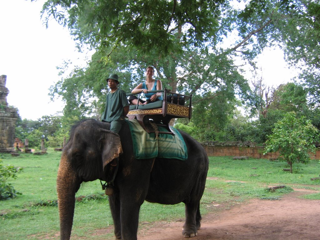
Pre Rup was Rajendravarman's state temple, built in 961. It consists of two enclosures with gateways at all four sides, a pyramidal structure, and five shrines on top. The two lower terraces are of laterite, the third upper terrace is of sandstone. The shrines are of brick. The entrances in the east and the false doors in the other sides are of sandstone. The false doors are delicately sculptured. Moulded pillars are on either side.Phnom Bakheng was were I went to see the sunset. I decided to have an elephant ride up to the temple-and for all my obsession with elephants as decoratation and in pictures, in person their skin is kind of ugly and riding them is simply not that exciting. It is slow, with a gentle rocking motion. Tons of people were taking pictures of me in the little basket, on the elephant, so I threw (not without being more than a tad worried) my digital to one of them to get a picture myself. This is not how I cracked the camera, though, that happened when it, and I, bounced off a temple wall. And no, such things are not very bouncy. The camera and I both looked worse for the wear afterwards. I got there early, so I read while I waited for the show to start. Sunsets occur very, very slowly. I am obviously too modern and used to watching TV cause I kept wanting to speed up the action. And as sunsets go, it wasn't fantastic, but then, one can hardly expect to schedule in a good sunset, they just happen when you least expect them and don't always correspond with picturesque locations. There are also a ton of tourists all there to see the sunset, so it isn't exactly a relaxing experience either. Walking down the hill, on broken stone steps, was an adventure.
The rulers of Angkor constructed many temple mountains, but Phnom Bakeng is all natural stone. The temple on the summit was built in the late 9th or early 10th century by Jacawarman I (or Yasovarman I). At the top of the hillock are 5 successive rows of 12 sanctuaries each. Here the Royal Linga - phallic symbol of the King in his divine state - was placed. More recently used as an observation post by armed forces, the site has deteriorated. The south-eastward view over the forest to the Angkor Wat towers is unequalled and the sunsets to the west over the countryside are often spectacular.
On his accession in 889, Yasovarman abandoned Hariharalaya (Roluos), the rudimentary capital of his predecessors situated on the plain, and became the first, seduced by the mysticism of the hills, to find his "Meru" (the seat of the gods) and his "Ganga" (the river Ganges) symbolised here in the hill of Phnom Bakheng and the river of Stung Siem Reap - the latter probably being diverted to follow the eastern boundary of the new city.
The two lions framing the bottom of the path which leads to the upper plateau are amongst the finest and the best proportioned to be found in Khmer art. The temple appears from here as a stack of five bare-faced tiers, becoming progressively smaller from 76m.00 at the base to 47m.00 at the summit, with an overall height of 13 metres. The severity of the lines is fortunately broken by the cut of a steep axial stair inclined at 70%, flanked by lions at each rise and framed by the cascades of small sanctuary towers that are repeated at the corners. The upper platform, with the quincunx of towers that are either truncated or have disappeared altogether, is no longer imposing, while the brick towers encircling the base of the pyramid are for the most part ruined and barely worth mentioning.
Thirty six of these towers, opening to the east and sometimes pierced subsequently with another door opening to the west, stood aligned in a single rank - except on either side of the axial pathways where they are found coupled on a common base, making a total of forty four. Many of them are missing or remain incomplete. Just before their remains, on the left, are two large pedestals. Found during the clearing work, these are remarkable in detail and quite pure in style.
Angkor Wat - Day 3
I started my day early, and went to see the sunrise at Angkor Wat. Like the sunset, it wasn't exactly the most marvellous sunrise I've ever seen, but it was nice. Wish I had gone to bed a bit earlier though! I then did a balloon ride, which was cool. It was a static balloon, which means it was connected to the ground by a steel cable, and only went up. It was a cool view of Angkor Wat and of the surrounding rice paddies.
My aim was to see the Rolous Group - Lolei, Preah Ko, Bakong. The first two weren't much really, though both Lolei and Bakong have active wats inside. At Bakong, which was quite beautiful, a little boy gave me a ring made out of a flower, it was really sweet.
Lolei was built by Indravarman's son (Yasovarman I, 889-915) on an island in the middle of a now dried-up baray. Originally intended as a 6-tower (3x2) plan like Phrah Ko, only four towers were built.
Preah KO, which means "the sacred bull" (Shiva's vehicle Nandi), was built by Indravarman I in 879. It is part of the Roluos group of monuments about 13 kilometers east of Siem Riep. The temple is distinguished from others in the area by the unusual arrangement of its six central towers, which stand in two rows facing east. The three towers on the east side are staggered so that the central tower is slightly further to the west. This tower is dedicated to Shiva, the Hindu god closely associated with the rule of Jayavarman II, the founder of the Khmer Empire. The tower to the north was dedicated to the founder of Preah KO, and the tower to the south was dedicated to the King's father. Each of these shrines once contained a statue, but they were removed at some time in the past.
The three towers to the west, which are shorter, were built for the spirits of former queens. According to the archaeologist Jean Laur, who spent a lifetime researching the Angkor monuments, the "octagonal colonettes surrounding the doors are among the finest examples of decorative carving in Khmer art" (Laur, p. 306).
The Bakong is the main temple of the Roluos group, some 13 km east of Siem Reap. It predates the big temples like Angkor Wat and the Bayon as it was built around 881. Before the era of Angkor Thom the capital of the empire was around Roluos. Parts of a laterite highway have been found linking it a Khmer city near Phimai in present day Thailand , some 225 km away.
I intended to have a shorter day, and relax a bit, so my last stop was the Mine Museum. It is run by a man who works clearing mines and many child victims of land mines also work and are educated at the museum. It was fascinating to learn about the different types of mines and also to read that the US is the only Western country who refuses to sign the treaty to ban land mines. I did know that already, but seeing the very dodgy countries on the rest of the list really emphasized how crazy it is.
It was at the Mine Museum that I got a monkey stuck in my hair. I can imagine this doesn't happen that often. It was climbing on my back and I was getting someone to take a picture for me when it tried to climb on my head and then jump off. Unfortunately for both the monkey and I, it got stuck in my ponytail. A rather amusing few moments of panicked monkey ensued, until a British tourist helped free it.
On my way home I stopped at an internet cafe, and a power outtage ate my post. Hence these have been written rather long after the fact, and are so undetailed. Such is life, I guess.
I haven't been commenting on the nightlife in Siem Reap, but it was fun. I learned a neat trick in the Laundry Bar, trying to pick up a box of matches with the second and forth fingers, with the middle finger always on the table, and the others never touching the table, and lifting it onto the top of a cigarette pack. Not easy, let me tell you. And the Angkor What? was a great little place, complete with a tiny dance floor and some great music.
posted by Amanda at 4:41 AM 0 comments
Basic History of Angkor Wat Temple Complex
Here's a translation of Maurice Glaize's popular and definitive 1944 guide to the Angkor Monuments for free.
The Khmer Empire was already well established by the time it came to Angkor in the early 900s. Yasovarman I was the first king to take up permanent residence, moving from his former capital at Hariharalaya (Rolous), where he had lived for twenty seven years. The new capital, called Yasodharapura,was quickly marked by the construction of a temple on Phnom Bakheng, the site's highest hill. Yasovarman also left his mark indelibly on the landscape with the construction of an enormous baray (reservoir) 7 kilometers long and 2 wide. It is thought that the waters of this baray met the needs of the fortified city he established around Phnom Bakheng and helped nearby farmers grow food during the dry season.
After Yasovarman's death various sovereigns transferred the capital to several sites, some far afield. Eventually they returned to Yasodharapura (Angkor) around 950. The sovereign Rajendravaran II constructed his state temple at Pre Rup and honored his ancestors with the construction of the five towers of Mebon in the East Baray. Other sites added in these years were built not by royalty, but by high-ranking nobles. Srah Srang built the beautiful stone landing at the edge of the Baray, and the nobleman Yajnavaraha constructed the remarkable Banteay Srei temple at a sight outside Angkor. After Ranjendravarman's death in 968 his son, Jayavarman V lived under the tutelage of the temple-builder Yajnavaraha and then declared the founding of a new capital, perhaps at Ta Keo. However, both projects were left unfinished at the time of the King's death in 1001.
The death of Jayavarman sparked a dynastic struggle for about ten years that prevented King Suryavarman I from taking residence at Angkor until about 1010. Once there, he consolidated his authority and expanded the Khmer empire through military campaigns against neighboring states. Although he mostly founded temples outside of Angkor, it is thought that he also began the construction of Angkor's West Baray, which was not completed until the rule of his nephew, Udayaditiavarman II. This nephew, who took power following Suryavarman's death in 1049, also constructed the Baphuon temple that later awed the Chinese emissary Zhou Daguan.
Other Kings descended from Suryavarman I continued to rule until 1080, when the dynasty came to an end. The kingdom was beset by attacks from Champa armies that would herald greater losses to come. In the meantime, Angkor enjoyed its golden age.
Suryavarman II began his rule in 1113 and died in 1150. Over his long reign, he was responsible for the construction of Thommanon and Chau Say Tevoda temples and others outside of Angkor. A strong ruler, he attacked armies on all sides of the empire, enlarging the kingdom. However, Suryavarman is best known for building Angkor Wat--the royal temple and tomb of world acclaim.
After Suryavarman's death the kingdom fell into disarray and Angkor itself was sacked by the Chams in 1177. They remained for four years in Angkor until the future Jayavarman VII, who had been reared in Cham territory, retook Angkor for his ancestral people and proclaimed himself King. He then launched a counterstrike against Champa lands and annexed them in 1190. They remained a part of the Khmer Empire for thirty years. During this time, Jayavarman constructed the walled city Angkor Thom and the Bayon temple at its center, fortified in case of another invasion.
Successors to Jayavarman had to battle an attack of Thai forces in 1285 and the coming of the Mongol hordes. They also had to come to terms with cultural factors that were turning Southeast Asia away from Indian Civilization and more toward the Theravada Buddhism of the type practiced in Thailand. Under the old system, the King was held to be a God among Hindu peers. Theravada Buddhism weakened the Kings' claims to divinity, perhaps undermining their authority.
In any case, no reliable records of Angkor Kings are available after 1307. Legend says that the Kingdom was annihilated by the Thais in 1431, but it seems more likely that significantly weaker Khmer Kings continued to hold furtive power. Evidence for this are inscriptions on the monuments themselves that record the presence of a Khmer Royal Court in the 15th century. Some Europeans, namely Spanish and Portugese, even managed to visit the ruins at that time.
The modern rediscovery of Angkor occurred in the late 19th century, when French expeditions laid the groundwork for much of the conservation operation to follow. Today, the French remain leaders in the restoration and conservation of the city of Angkor.
Last day in Cambodia
Cambodia was a hard country to leave-I would have loved to have had longer to explore more of the country, outside of the main tourist track.
I had chatted before with a girl from Columbia who had been living in London, and ended up going to the Butterfly Garden with her and a girl from the Netherlands. Most of the people I met in Cambodia were European and I don't recall meeting a single Canadian, though there was the odd American. The garden was run by a foreinger and a group of Cambodian children collected the butterflies and used their wages to pay for school. I like the blue butterflies best, of course.
Then we went to Psar Chas, the old market, and wandered around. After a quick recon of all the stalls and a look at the food section, with the meat and live fish as well as vegetables, I went back and spent all of my money, leaving myself only enough for the exit visa and my moto ride to the airport. I went back to the guesthouse to have a quick shower before leaving.
The airport was tiny, and I ended up using my credit card to pay the leaving tax, which gave me cash to buy food and stuff in the airports. I didn't manage to sleep at all on the plane, and I must say arriving Monday morning exhausted made teaching that much more interesting...
All in all, one of the most fantastic trips of my life.
No comments:
Post a Comment